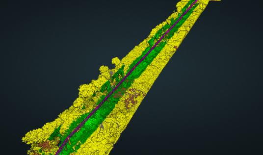
Picture this: A utility company faces mounting pressure to prevent power outages caused by vegetation encroachment, but manually inspecting thousands of miles of power lines takes months and costs millions. Traditional approaches rely on helicopter surveys and ground crews walking corridors, often missing critical areas or identifying problems too late to prevent outages.
Now imagine the same scenario with AI-powered spatial analysis. Point cloud data from routine LiDAR flights automatically identifies vegetation encroachment within 10 feet of power lines across the entire network. The AI system doesn't just flag problem areas—it calculates clearance distances, predicts growth rates, and prioritizes maintenance crews. Suddenly, that utility transforms from reactive crisis management to strategic prevention.
This transformation represents the fundamental shift that GeoAI is bringing to spatial decision-making across industries.
The Executive's Dilemma
Every organization working with spatial data faces the same challenge: extracting actionable insights from increasingly complex datasets fast enough to drive competitive advantage. Traditional approaches create cascading business problems:
Point cloud classification projects stretch from days into weeks as analysts manually segment millions of data points Transportation departments spend months identifying vegetation encroachment, discovering problems only after outages occur Engineering firms lose competitive proposals because their analysis timelines can't match client expectations
These aren't just operational inefficiencies—they're strategic vulnerabilities. Manual classification introduces human inconsistency, where the same dataset might be interpreted differently by different analysts. The hidden costs multiply through rework, missed opportunities, and competitive disadvantage.
Perhaps most critically, "good enough" data quality is no longer sufficient in today's competitive landscape. Clients expect detailed, accurate analysis delivered quickly. Regulatory requirements demand higher precision. The margin for error continues to shrink while dataset complexity grows exponentially.
AI Fundamentals Without the Jargon
At its core, AI transforms how we extract meaning from spatial data by recognizing patterns at previously impossible scale and speed. Traditional rules-based systems work like detailed instruction manuals: "If points form a surface above ground level with specific geometric properties, classify as building." These systems require extensive manual programming and struggle with edge cases.
Machine learning takes a fundamentally different approach. Instead of programming rules, AI systems learn patterns from examples. Show an AI system thousands of correctly classified point clouds, and it develops mathematical understanding of what distinguishes buildings from vegetation, roads from rooftops, or healthy infrastructure from stressed materials.
The power lies in multi-dimensional analysis. While human analysts focus on height, surface orientation, or point density one characteristic at a time, AI systems evaluate dozens of geometric properties simultaneously. This reveals patterns invisible to human perception—early geometric signatures of structural stress, subtle spatial relationships indicating environmental changes, or complex feature combinations that distinguish similar-looking objects. Companies like Crescer AI are pushing these boundaries, developing systems that can classify point clouds with unprecedented speed and accuracy.

Business Impact: The Numbers That Matter
The transformation becomes clear across four key dimensions:
Speed: Industry benchmarks show classification projects requiring 2-3 weeks of manual analysis completed in 3-4 hours with AI systems. One engineering firm reported reducing their workflow from 80 hours to 2 hours—a 97% time reduction.
Accuracy: Modern AI classification achieves 92-95% accuracy for common object categories, compared to 60-70% from traditional automated methods. More importantly, AI provides confidence scores, allowing analysts to focus verification efforts on uncertain areas.
Scale: Organizations can now process citywide datasets containing billions of points, analyze historical archives for long-term trends, and continuously monitor infrastructure rather than relying on periodic inspections.
Consistency: AI systems eliminate human variability, applying uniform classification logic across datasets, time periods, and geographic regions. This enables meaningful comparisons and reliable integration with automated decision-support systems.
Implementation Realities
Successful GeoAI implementation requires realistic expectations:
Data and Timeline Considerations
- Data quality drives AI performance. Organizations with diverse, well-documented datasets see faster implementation and better results
- Plan for 3-6 months to fully realize productivity gains, including 1-2 months for technical deployment and additional time for organizational adoption
- Change management becomes critical as technical teams learn to work with AI tools and integrate them into existing workflows
Build vs. Buy Decision Framework
Most organizations find better value in commercial platforms offering pre-trained models with customization options rather than building custom solutions. Advanced systems like Iris demonstrate how AI can deliver super-fast, accurate results at a fraction of traditional costs. The key is finding solutions that integrate well with existing workflows while providing flexibility for specific needs.
Strategic Positioning for Competitive Advantage
GeoAI capabilities create advantages that extend beyond operational efficiency. Organizations successfully implementing AI-powered spatial analysis position themselves for strategic opportunities while mitigating risks affecting their competitors.
Competitive differentiation emerges from capabilities rather than cost. Companies can bid on projects requiring rapid analysis, offer previously unfeasible services, and deliver insights competitors cannot match. Early adopters develop institutional knowledge and refined processes that become increasingly difficult to replicate.
Future-proofing becomes essential as client expectations shift toward advanced analysis capabilities. Organizations that delay AI adoption risk being unable to compete for projects requiring sophisticated spatial intelligence.
AI Readiness Assessment
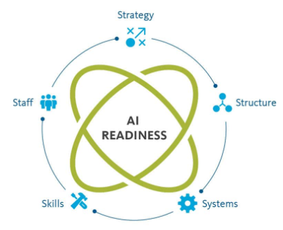 Evaluate your organization's potential across these factors:
- Data Assets: Volume, quality, and diversity of existing point cloud datasets
- Technical Infrastructure: Current processing capabilities, cloud access, and integration requirements
- Organizational Readiness: Team expertise, openness to new tools, and change management capacity
- Strategic Alignment: Specific use cases where AI creates competitive advantages
- Investment Capacity: Ability to invest in technology and organizational change
Start with well-defined applications rather than attempting to transform everything simultaneously.
The GeoAI revolution isn't coming, it's here. Organizations that understand these fundamentals and take strategic action will lead their industries into the next era of spatial intelligence. Those that wait risk being left behind in an increasingly competitive landscape where data quality, speed, and analytical sophistication determine market success.
The question isn't whether GeoAI will transform your industry—it's whether your organization will be leading or following that transformation.
Ready to explore how AI can transform your spatial analysis capabilities? Contact us to learn more about Iris and discover what's possible when advanced AI meets your point cloud data.